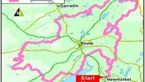
Taking six-days to complete, the Mid Clare Way connects with the East Clare Way near Tulla and encircles the county town of Ennis.
Stretching 148km in total, the terrain consists mainly of quiet tarmac side roads and farm roads, with only brief sections across forestry track and field. About 96km of this route follows local roads.
Touching on the breathtaking Burren to the north and the broad Shannon Estuary to the south, expect secluded legs over remote hills, peaceful river valleys and serene lake shores. This moderate route ascends 1,620m overall.
Climbing to the western slopes of the Slieve Aughty range, enjoy wonderful views across to Mullaghmore and the Burren, and explore the idyllic nature reserve at Dromore Woods.
A number of overnight accommodation options are available across this route. Near the seven trailheads – Newmarket-on-Fergus, Quin, Ballinruan, Ruan, Connolly, Lissycasey and Clarecastle – you’ll find plenty of spots for rest and refreshment.
Trail details
- Type:
- Long Distance Waymarked Way
- Location:
- Newarket on Fergus
- Grade:
- Moderate
- Format:
- Loop
- Length:
- 143.90km
- Ascent:
- 1620m
- Dogs allowed:
- No
At Start - on street or in car parks in Newmarket on Fergus
At End - on street or in car parks in Newmarket on Fergus
- With the Burren Way to the north and the East Clare Way to the east, the Mid Clare Way, also known as Slí na Mearacan or the Foxglove Way, loops around the centre of County Clare.
- The highest point the route reaches (267m) is just below the summit of the wooded hill of Ben Dash, west of the tranquil River Fergus estuary.
