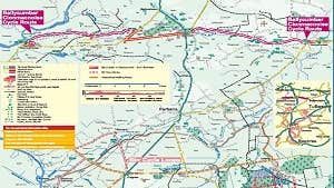
The Pilgrim’s Road from Ballycumber to Clonmacnoise monastic site, is a linear route which runs along the crest of an esker.
Eskers are sinuous rides that rise above the otherwise generally flat landscape. They are made of sand and gravel that was laid down in meltwater tunnels beneath the glaciers that covered central Ireland at the end of the last Ice Age, 12,000 years ago. When their supporting banks of ice finally melted, the beds of these sub glacial rivers were left standing above the landscape. For centuries the dry well-drained esker ridges have provided important natural lines of communication. For pilgrims, the esker route was dry underfoot, relatively level and afforded a view over the surrounding countryside, which can be enjoyed today by bike.
Pilgrim’s Road to Clonmacnoise: 24.4km
Start: Ballycumber/Clonmacnoise
Cycle Route Marking: Red
Leaving Ballycumber turn right out of the village when the road veers left. After a short uphill stretch 2km on pass by Lis church, now a private residence. 3km further on is Boher village, stop to see the 12th century St Manchan’s shrine in the church and its Harry Clarke studio windows. There is a walking route from Boher to the Early Christian Monastic site of Lemanaghan, the home of the shrine.
After another 4.7km there is a sign for St Manchan’s well on your left. 10km further are the crossroads at Doon with views of Togher castle on your right and Esker castle on the ridge behind it. Cross over the N62 and proceed to the R444 with caution to Mannion’s Crossroad. Turn right and then wheel left to rise up onto the next stretch of esker.
As you approach Clonmacnoise the view is stunning with Mongan’s Bog on your left, the Shannon Callows on your right and Clonmacnoise round tower ahead. The first contact with Clonmacnoise is the Nun’s church on your left. Access to the modern graveyard is ahead of you but carry on round to the entrance gates of Clonmacnoise to the south.
Trail details
- Type:
- Road Cycling Trail
- Location:
- Lemanaghan Clonmacnoise
- Grade:
- Moderate
- Format:
- Linear
- Length:
- 24.40km
- Ascent:
- 111m
