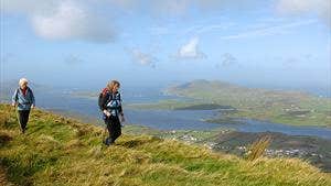
In his song The Boys of Barr na Sraide, Sigerson Clifford describes Cahersiveen as ‘the town that climbs the mountain, and looks upon the sea.’ The town lies at the foot of Beentee Mountain, on the Fertha River, and overlooks Valentia Harbour. It is the main centre for the western end of the Ring of Kerry and is an ideal location for exploring the rugged coast of the southwest of Ireland. Cahersiveen has a superb yachting marina and harbour and has a reputation for some of the best deep sea angling in Europe. The area is of great importance and interest to antiquarians as it boasts many ancient sites including the ruins of the 15th century Ballycarbery Castle; and two dry stone forts (Leacanabuaile and Cahergal) which date to 800 AD. In the townitself, the Old Barracks Heritage Centre is a unique building of Schloss design which was completed in 1875. The trailhead for the Beentee Loop is in the centre of the town and starts by following an ancient mass path – then rising to gentle mountain slopes. A steep climb takes you onto the summit of Beentee Mountain (376m) which overlooks the town, the harbour and much more.
A-B. Starting from the trailhead at The Fairgeen Car Park in the heart of the town, follow the blue arrows and purple National Loop arrows out the rear of the car park and ascend via Carhan Lower passing the water reservoir from where you have a panoramic view of the town and Valencia Harbour. You are also on the Kerry Way (a long-distance route) marked with yellow arrows and the familiar trekking man logo. After 1.5km the loop joins an old mass path through Carhan Upper.
B-C. Follow the Mass path along the lower slopes of Beentee Mountain to join a tarred surface at Gurteen. After 300m watch out for a signpost which directs you to the right across a stile onto a track which ascends steeply by the side of forestry onto the ridge south of Beentee.
C-D. At the end of the steep ascent, the loop swings sharp right and continues to climb along the ridge following ditches and wire fences (on your left). Near the end of the ascent, the loop crosses a stile and takes you onto the summit of Beentee from which you have spectacular views of the town, the harbour, and the marina.
D-E. Continue to follow the blue arrows as you descend to Garranebane by well worn paths and, towards the end an old laneway. The end of this section exits onto a tarred roadway where you turn right.
E-A. The final 1km section takes you back to the trailhead via minor roads at the back to the town.
Trail details
- Type:
- Walking Trail
- Location:
- Cahersiveen Loops
- Grade:
- Strenuous
- Format:
- Loop
- Length:
- 9.50km
- Ascent:
- 420m
- Dogs allowed:
- No
