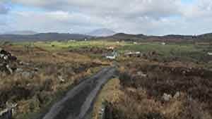
A-B. From the trailhead follow the purple (and yellow) arrows downhill for about 300m to reach a 3-way junction. This is the point from where the loop ‘proper’ begins - you will be returning to this point from the left later. For now - continue downhill along the roadway. (Note: The yellow arrows are for the long-distance Foxford Way - you will be overlapping on this route for much of this loop.) After another 500m you reach a junction where you turn left and travel along a laneway through the townland of Roosky. At a T-junction, turn left onto the grassy roadway and enjoy the trip through the old tree-lined grassy laneway. Joining a ‘main’ road turn left and, almost immediately, left again. After 100m take note as the Foxford Way turns right - but you continue straight.
B-C. After 100m the Foxford Way turns right - but you continue straight ahead. You are now in the townland of Bohernahallagh. Enjoy your journey past a series of pleasant farming homesteads, and turn left at a junction after 600m. Two quick right bends takes you onto a ‘straight stretch’ - after 700m arrive at a 3-way junction where you have the chance to take a slight detour (100m) to visit a Holy Well and Graveyard. The loop continues straight.
C-D. Continue to follow the purple arrows as the loop ascends along a minor roadway for almost 2km where the Foxford Way joins again from your right. After another 1km watch for a waymarker on your left which directs you over a stile and onto a ‘green’ mountain path.
D-A. Now you tackle the most challenging section of the loop as it ascends to a height of 270m - but the views behind and in front of you when you cross the summit are rewards indeed. Descend to join a gravel roadway and eventually reach the junction in Glanduff mentioned in A above. This time turn right (uphill) and enjoy the last 300m back to the trailhead.
Trail details
- Type:
- Walking Trail
- Location:
- Foxford
- Grade:
- Moderate
- Format:
- Loop
- Length:
- 11.40km
- Ascent:
- 280m
- Dogs allowed:
- No
