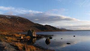
Easkey is a coastal village on the Atlantic coast of County Sligo. The village name derives from the Gaelic term for fish – the word 'iascaigh' literally means ‘abounding in fish’! The source of the fish is the Easkey River that flows through the village and into the sea. The river, which is known for its salmon and trout, rises at Lough Easkey approximately 20km away. The lake is located in the middle of the Ox Mountain range and lies between Lough Talt (to the south) and the village of Dromore West (near the north coast). It is a beautiful lake surrounded by the odd outlying house or building and bog land and small forest plantations. The general area is popular for its highly attractive scenery and the growing range of outdoor sports including walking, surfing, kayaking and fishing.
A-B. From the trailhead, follow the purple arrow for just 30 metres to a junction with a sandy roadway going left on the lakeshore. Note that a yellow arrow (for the long distance Sligo Way) points straight on here, but you turn left onto the lakeshore. Continue to follow the sandy roadway for 800 metres to reach a bridge over the Easkey River. After another 100 metres the loop turns right at a fenced area (water treatment plant) and then turns left to follow parallel to the lakeshore.
B-C. Follow the purple arrows as the loop travels along the lakeshore for almost 2 kilometres. Towards the end of the lakeshore section the loop turns right and ascends above a derelict farmhouse and buildings. Shortly afterwards it descends to join an old laneway and continues along the lakeshore for more than 500 metres to reach a point where the Sligo Way (yellow arrows and walking man) joins from your right. Continue straight at this waymarker, staying on the lakeshore.
C-D. The laneway continues for almost 1 kilometre along the shoreline before veering right and crossing some open ground by a farmhouse to reach a surfaced road, turn left here.
D-A. It’s only 1.5 kilometres back to the trailhead - enjoy the views!
Trail details
- Type:
- Walking Trail
- Location:
- Lough Easkey
- Grade:
- Moderate
- Format:
- Loop
- Length:
- 6.10km
- Ascent:
- 90m
- Dogs allowed:
- No
