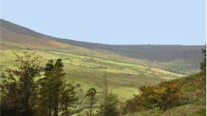
Lead, zinc, copper, sulphide and barites have been mined in the area since Roman times - Silvermines is named after a former silver mining site. Active mining ceased here in 1993. To the south of the Silvermines Mountains is the highest peak in the mountains, Keeper Hill which rises to 695m and dominates the area. The village marks the end-point of the waymarked Slieve Felim Way which starts 30km away in Murroe, County Limerick. This loop explores the Coolyhorney area, overlaps with the Way for a short period.
A-B. Starting from the car park, enter Knockanroe Woods via the metal barrier and follow the red arrows along the forestry road. Note that the first stage of the loop overlaps with the long-distance Slieve Felim Way - marked with the familiar yellow arrows and walking man symbol. After 200m, turn left at a crossroads. Just 200m after turning left, the loop passes wooden steps on the right - where the loop rejoins on the return journey. For now, continue straight.
B-C. Continue to follow the red arrows (and the yellow arrows of the Slieve Felim Way) for almost 1km to reach a
Y-junction where you veer right – and leave the Slieve Felim Way.
C-D. After ascending along a forestry road for 1km, the terrain changes to a ‘green’ track as the loop enters trees. Continue to ascend through forestry to exit at two wooden pillars. Turn right and join a sandy track.
D-B. After 200m along the sandy roadway you take the last steep ascent from where there are spectacular views of the Silvermines area and Keeper Hill. On the descent, the loop veers right at two Y-junctions, enters a forested section and, after a short flat section, turns left to descend along a narrow walking track to reach the wooden steps mentioned earlier.
B-A. Turn left and shortly afterwards turn right at the crossroads – from there it’s only 200m back to the trailhead.
Trail details
- Type:
- Walking Trail
- Location:
- Knockanroe Woods
- Grade:
- Moderate
- Format:
- Loop
- Length:
- 4.10km
- Ascent:
- 150m
- Dogs allowed:
- Yes
