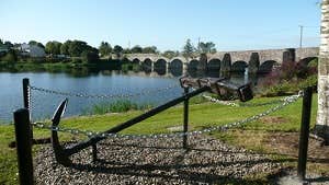
The picturesque village of O'Briensbridge, County Clare nestles on the banks of the River Shannon and borders three counties namely Clare, Limerick and Tipperary. The twin village is linked to its sister village, Montpelier in County Limerick on the other side of the river Shannon, by a 15th Century stone bridge.
The first bridge at this point was built in 1506 by Turlough O'Brien, First Earl of Thomond. It was a wooden structure and was destroyed during a rebellion against the Crown in 1510. The O'Briens then constructed a "Great Bridge", with marble castles at either end for defence. These castles were built in the water, had walls 12 feet thick, and were connected by a massive wooden bridge of seven arches, 15 feet above the water line. However, in 1537, the O'Briens sided against the Crown in another rebellion, and following a battle lasting several days the "Great Bridge" was taken and eventually destroyed. The present stone bridge was built around 1750, though 6 of the arches on the eastern side were replaced in 1842.
From the late 18th century, O'Briensbridge was the main port between the two ends of the Limerick Navigation system, which used three canals and two river sections to bypass the shallows of the lower Shannon. This system was part of transport network comprising steamers, barges, and railways which linked the west of Ireland's agricultural exports to the main markets in Great Britain.
The short 4.7km loop is marked with green arrows and travels upstream along the Shannon to the Parteen Weir Hydro Dam before returning to O'Briensbridge via the Headrace Canal. The loop is part of the network of National Looped Walks and is marked in both directions using the standard National Looped Walk directional arrows.
Tips: The loop starts and finishes at the trailhead which is located on the bank of the river Shannon at the Riverside Park in the village of O'Briensbridge, approximately 14km from Limerick City and just off the R463. The trailhead car park is located close to a variety of local shops, pubs, restaurants and guest accommodation.
Trail details
- Type:
- Walking Trail
- Location:
- O'Briensbridge Loop Walks
- Grade:
- Easy
- Format:
- Loop
- Length:
- 4.70km
- Dogs allowed:
- Yes
